$0.00
Your Basket
Your basket is empty.
Added to Basket
ff2b8c839d8be6b63c55fd9db4dbb2ab
$ USD
Login
/
Register
Advanced Search
Please enter a search keyword
Advanced Search
Please enter a search keyword
Home
World War II
Pacific Theater
Iwo Jima
Relief Map of Iwo Jima
Home
Automobiles
Aviation
Aviation
Airships & Blimps
Propeller Planes
World War I
World War II
Wright Brothers
Test Aircraft "X-Planes"
Test Aircraft "X-Planes"
Boeing XB-47
Bell X-1
Bell X-2
Douglas X-3
Northrop X-4
Bell X-5
North American X-15
Martin X-24
Northrop XB-35
Douglas XB-43
Consolidated XB-46
Martin XB-48
North American XB-70
Cities & Towns
Color Images
Gas Stations
Landmarks
Lithographs
Motorcycles
Panoramic
Pinup
Space - NASA
Space - NASA
Mercury
Apollo Test Project
Apollo 1
Sports
Sports
Baseball
Boxing
Trains & Railroads
Trucks
US Civil War
US Civil War
African Americans
Artillery & Equipment
Battlefields
Cavalry Units
Cities & Towns
Fire & Medical
Forts & Camps
Infantry Units
Portraits & Officers
Railroad
Signal Corps
Vessels & Warships
World War I
World War I
Battlefields
Homefront
Red Cross
Ships & Vessels
Tanks & Armament
World War II
World War II
Battle of the Bulge
Battle of Britain
D-Day
D-Day
Operation Overlord
D-Day - 6 June 1944
D-Day+ Normandy Area
Mulberry Harbor
Eastern Front
European Theater
European Theater
France
Germany
Belgium
Netherlands
Austria
United Kingdom
Germany
Home Front
Market Garden
North Africa
Pearl Harbor
Pacific Theater
Pacific Theater
Iwo Jima
Okinawa
Gilbert Islands
Marshall Islands
Solomon Islands
China-Burma
Mariana Islands
Japan
Philippines
Midway
Peleliu
Malaysia
Aleutian Islands, Alaska
New Guinea-Australia
Indonesia
People
Red Cross & Medical
Tanks & Artillery
V-E & V-J Day
War in Color
Popular Products
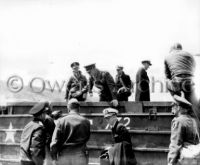
Allied Generals on Amphibious DUCK Omaha Beach
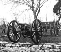
Wiard 6-pound gun, Washington, D.C.
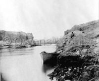
Dutch Gap Canal, April 1865
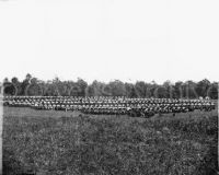
Large war wagon park at Brandy Station
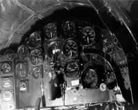
Bell X-1 cockpit instrument panel
Terms & Conditions
Our Guarantee
Contact Us
About Us
Copyright & Trademark
Safe & Fast Checkout
JavaScript is required by this website. Please enable this in your browser settings.
×
Relief Map of Iwo Jima
$0.00
Free!
Select Option(s) For Price
Add to Basket
Product Information
"Relief Map of Iwo Jima --- U.S. Navy carrier pilots were briefed for their strikes against Iwo Jima through the use of detailed relief maps such as this one". Quoted from the original photo caption, filed 6 April 1945. Mount Suribachi, at the island's southern end, is in the lower right.
Product Code
Iwo Jima 246
Customer Reviews
This product hasn't been reviewed yet.
Write a review
Write Review
Name
Email
Rating
Review Title
Review
Please enter a valid email address.
This field is required.
Top